Entries in photo (8)

Sunday
Aug222010

Trip Report: Glacier National Park - Huckleberry Mtn & Piegan Pass

Sometimes ignorance is bliss.

The aptly named Huckleberry Mountain is famous for the huckleberry bushes found along its trails. Unfortunately, besides hungry hikers, bears also frequent this area. So much so that, Backpacker Magazine named this hike one of America's 10 most dangerous hikes ( October 2008).

For us, fortunately, the hike was an uneventful, unending, ascent which culminated in a great view and an even better Huckleberry cobbler at dinner.

the trail to the summit (as seen from Huckleberry Mtn's summit)


Ptarmigan on the Huckleberry summit


The next day was the "worst" day of the trip; the one day where the weather didn't cooperate. The plan was to hike Piegan Pass and learn about animal tracking, however we had to truncate the hike due to the weather (rock scrambling + rain = trouble).

Fortunately, damp ground makes animal tracking much easier, so the guide was able to easily show us and challenge us to identify tracks.

Midway into the hike, we happened upon a couple from Seattle heading down the trail. They had found bear scat and, not knowing how recent or whether it was from a Grizzly or Black bear, decided to retreat.

Our guide offered to help them identify it, and after a few minutes of hiking, we were all gathered around the bear droppings.

The guide went through how to differentiate bear scat (large volume, like a gallon, is generally Grizzly), how to avoid surprising bears (keep talking to each other or yourself), and why they needn't worry today (you have bear spray and the wind at your back, so your scent will prevent you from startling the bear).

Shortly after this lesson, the weather turned for the worst and we voted to abandon the hike. On the return trip, however, we spotted a goat over a mile away

Can you spot the goat? (click for zoomed image)


In the end, the decision was a very good one. Despite the weather initially clearing, as we drove past Logan Pass this was the sight we were greeted with.

Jammers in the fog at Logan Pass
Friday
Aug202010

Trip Report: Glacier National Park - Logan Pass

Every year the Appalachian Mountain Club (AMC) working in conjunction with The Glacier Institute organizes a major excursion to Glacier National Park in Montana.

The tone of the excursion was set pretty early. After our welcome dinner, the manager of the Glacier Institute's Field Camp took us on a short hike around the camp. Not ten minutes into the hike, we happen upon a young Black bear.

We were walking in tall grass between the Flathead river and a road; we had just stopped to see if there were any coyotes among the horses in an opposite field, when a large four legged animal jumped up and ran through the grass, not 20 feet from us.

It wasn't until the animal stopped running, and stood on its hind legs that it became obvious (to those bear neophytes in the group, myself included) the large animal was a Black Bear. The bear stared at us for a little bit, before running off (encouraged by the noise the guide was making).

Not five hours into our trip and we had our first large animal sighting. The encounter changed the group somewhat. It is something to be told to be "bear aware." It is quite something else to actually have an encounter. The later guarantees you will take any bear tips very seriously.

The next day, we headed out early, for our "real" introduction to the park at Logan Pass.

Logan Pass sits on the Continental Divide and is the stopping point for most visitors traversing the park by car.

Two trails originate from this Pass, the southbound Hidden Lake trail and the northbound Highline trail. We started the day by heading south to see the Hidden Lake.

Hidden Lake

Hidden Lake

Almost immediately we were beset by wildlife: Goats grazing, Long Horned Sheep relaxing, and Pika foraging.

Goat

Wild Goat "admiring" the trail's flowers

On the Highline trail, in contrast, there were fewer animals to be seen; however a chance sighting of a Golden Eagle (and the view) made the trek immanently worth while.

Golden Eagle

Golden Eagle

The view from the Highline Trail


I had signed onto this trip to just see Glacier National Park and maybe some wildlife. In the first two days this trip exceeded all of my expectations.

Sunday
Aug012010

Trip Report: White Mountains, NH - Mt. Washington & Mt. Monroe

The hike up Ammonoosuc Trail was surprisingly easy. I had read stories of how Mt. Washington was tough, how it was more like a western (Rocky) mountain. However, on Ammonoosuc I saw, or felt, none of this.

At the Lake of the Clouds hut, I was feeling so strong, so confident, that I turned away from Mt. Washington and climbed to the summit of Mt. Monroe.

Lake of the Clouds hut and Mt. Washington, as seen from the side of Mt. Monroe.


The first thing that greats hikers, as they leave the Lake of the Clouds hut towards Washington, is a weather beaten warning sign: "STOP: The area ahead has the worst weather in America. Many have died there from exposure, even in the summer. Turn back now if the weather is bad."

The aforementioned warning


one of the Lakes of the Clouds


On the lower steps of Washington, there was a camaraderie amongst us hikers; we chatted, we joked, we laughed together. However as the final mile ground us down with its continuous, demoralizing, unending ascent, we withdrew, one-by-one, into that quiet mental place all athletes know. That place where your mind is clear, pain is ignored, and all that matters is the lifting of the left foot, followed by the right, and repeated ad infinitum.

All that mental stillness is broken by the bustle at the summit. Visitors who drove, or took the Cog Railroad up the mountain, rush around from one side to the next, children screaming or squealing in delight.

I don't want to give the wrong impression, although it was a bit of a shock, the summit experience was not bad. I've been on summits (without roads) that were far more crowded and less personable. Everyone at the top was respectful of the hikers, so much so that one visitor stopped me to congratulate me.

Mt. Washington Observatory


Trail leaving Mt. Washington


From the naturalists and the family celebrating their patriarchs 60th birthday, to the waterfalls and pools dotting Ammonoosuc, and the birds and other wildlife around Jewel Trail, it was a great day of hiking.


Distance: 9.1 miles
Time: 7 hours 40 minutes
AMC 4k peaks: Mt. Monroe, Mt. Washington
Wednesday
Apr142010

Trip Report: Yosemite National Park

Hovering between Winter and Spring, April gives Yosemite visitors a wonderful mix of weather. During the four days I visited, the temperature ranged from the 20s to the 60s (all temperatures Fahrenheit) with the weather fluctuating from sunny and clear to cloudy and snowing.

RT-140 heading towards the valley


The indescribable beauty of Yosemite becomes readily apparent during the long drive into the valley. With the old growth forest to your left and the wondrous vistas to your right, spectacular is the only way to describe the drive.

"Tunnel View" (RT-140)


In Yosemite, besides admiring the mountains, visitors should be on the lookout for animals of all kinds. I watched as a pair of deer grazed, unseen, not 30 feet from the Visitors Center; all eyes fixed upwards at the falls.

Yosemite Falls


Similarly, while hiking the Valley Loop Trail, I watched a black bear saunter in the opposite direction, not 20 feet from me; either ignorant of, or unimpressed by, my existence. Likewise, as I was leaving the park, I watched a solitary coyote trot along the edge of the RT-140.

An obscured Yosemite Falls from the Swinging Bridge


I stayed in Curry Village, a grouping of canvas tent cabins (canvas walls over a wooden structure. Heat is optional, but recommended for an April stay). The accommodations are simple: a cot, blankets, towels, and shared facilities. The experience is unforgettable; The first night I fell asleep to the pitter-patter of rain changing to snow. The second night, I witnessed a waterfall of snow (avalanche) off Glacier Point, the summit that looms behind Curry Village.


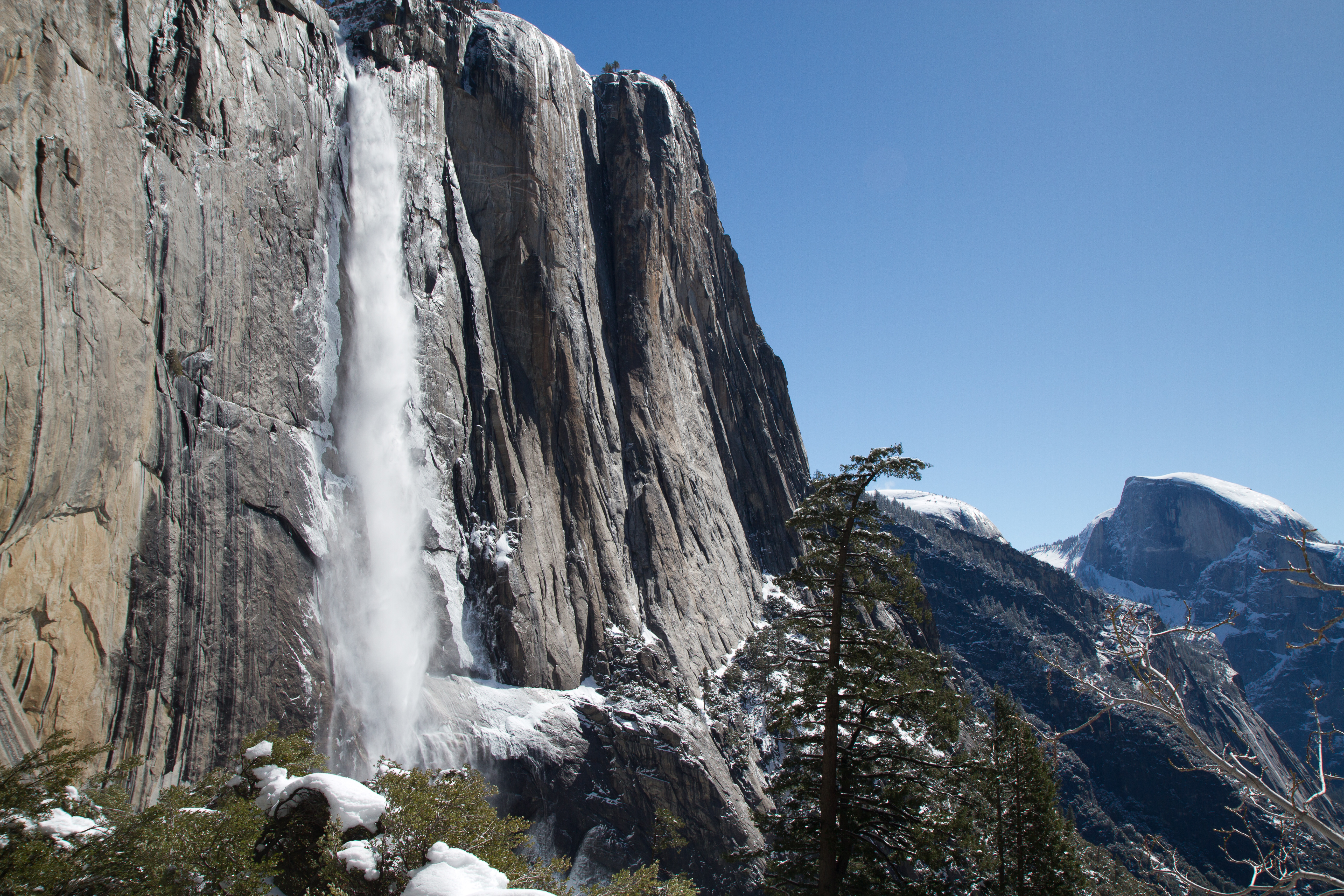
Upper Yosemite Falls and Half Dome, as seen from the Upper Falls trail. 


If you only have one day, the views in and out of the park, Lower Yosemite Falls, and the Valley proper will last a life time.

If you have more time, I strongly suggest the Upper Yosemite Trail. The hike is not an easy one, especially in April, but the views are worth it. My only tip: if you struggled to reach Columbia Rock, continue to "the gate." The views of Upper Yosemite Falls from that point make any the suffering worth it.

Sunday
Mar282010

Trip Report: Lost Dutchman State Park

Like Red Rock State Park, Lost Dutchman State Park is slated to close in June in an effort to alleviate Arizona's budget issues.

Siphon Draw Trail
Morning on the Siphon Draw


The majority of the park's visitors focus on the Siphon Draw Trail. In spring, the trail is awash in a sea of color as flowers scream for attention. And in the Basin, visitors are rewarded with a small desert waterfall.

The top of The Flatiron


Most hikers, however, do not complete the whole trail, which ultimately ends 4861ft above sea level at the top of The Flatiron.

In the two miles from the trailhead to the Basin, hikers gain a little over 1000ft in elevation. To reach the top of The Flatiron, you must gain 1760ft in one mile.

Siphon Draw Trail
Looking down on/from Siphon Draw


The first time I visited Lost Dutchman State Park, I (wisely) decided to save The Flatiron for another visit. At that point in the day, I had hiked all the other trails in the park and guessed Siphon Draw's final mile wasn't going to be trivial.

My Left Foot
My Left Foot


After reaching the top of The Flatiron, I am satisfied with my earlier decision: This is not an easy hike.

Throughout the ascent you need to be very aware of your feet, and confident in their placement. To this end, my choice of footwear helped immensely.

Vibram's FiveFingers KSO Treks are a "shoe" designed to give you all the benefits of barefoot running, walking, and hiking with the protection you expect from footwear. The Treks, specifically, are designed to handle the harshest trails.

These shoes allowed me to easily climb the toughest parts of the trail; I could put all my weight on my toes and feel the stability of my foothold. I could not imagine doing this hike without that feedback.

Superstition Mountains
Superstition Mountains as seen from Discovery Trail


In the end, hiking to the top of The Flatiron is difficult, but it is also very rewarding. If you have the time and physical fitness, it is one you should attempt before this park closes in June.


Distance: 6.6 miles
Time: 6 hours 30 minutes
Peaks: The Flatiron, Superstition Mountains (4861 ft)