Trip Report: Lost Dutchman State Park
Like Red Rock State Park, Lost Dutchman State Park is slated to close in June in an effort to alleviate Arizona's budget issues.
 |
| Morning on the Siphon Draw |
The majority of the park's visitors focus on the Siphon Draw Trail. In spring, the trail is awash in a sea of color as flowers scream for attention. And in the Basin, visitors are rewarded with a small desert waterfall.
 |
| The top of The Flatiron |
Most hikers, however, do not complete the whole trail, which ultimately ends 4861ft above sea level at the top of The Flatiron.
In the two miles from the trailhead to the Basin, hikers gain a little over 1000ft in elevation. To reach the top of The Flatiron, you must gain 1760ft in one mile.
 |
| Looking down on/from Siphon Draw |
The first time I visited Lost Dutchman State Park, I (wisely) decided to save The Flatiron for another visit. At that point in the day, I had hiked all the other trails in the park and guessed Siphon Draw's final mile wasn't going to be trivial.
 |
| My Left Foot |
After reaching the top of The Flatiron, I am satisfied with my earlier decision: This is not an easy hike.
Throughout the ascent you need to be very aware of your feet, and confident in their placement. To this end, my choice of footwear helped immensely.
Vibram's FiveFingers KSO Treks are a "shoe" designed to give you all the benefits of barefoot running, walking, and hiking with the protection you expect from footwear. The Treks, specifically, are designed to handle the harshest trails.
These shoes allowed me to easily climb the toughest parts of the trail; I could put all my weight on my toes and feel the stability of my foothold. I could not imagine doing this hike without that feedback.
 |
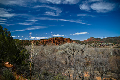
| Superstition Mountains as seen from Discovery Trail |
In the end, hiking to the top of The Flatiron is difficult, but it is also very rewarding. If you have the time and physical fitness, it is one you should attempt before this park closes in June.
Distance: 6.6 miles
Time: 6 hours 30 minutes
Peaks: The Flatiron, Superstition Mountains (4861 ft)
 hiking