Thursday
Aug192010
Glacier National Park - Trip Update
I appologize for the delay in posting my trip report(s) for the Glacier National Park trip, in the meantime, enjoy some pictures from the trip: 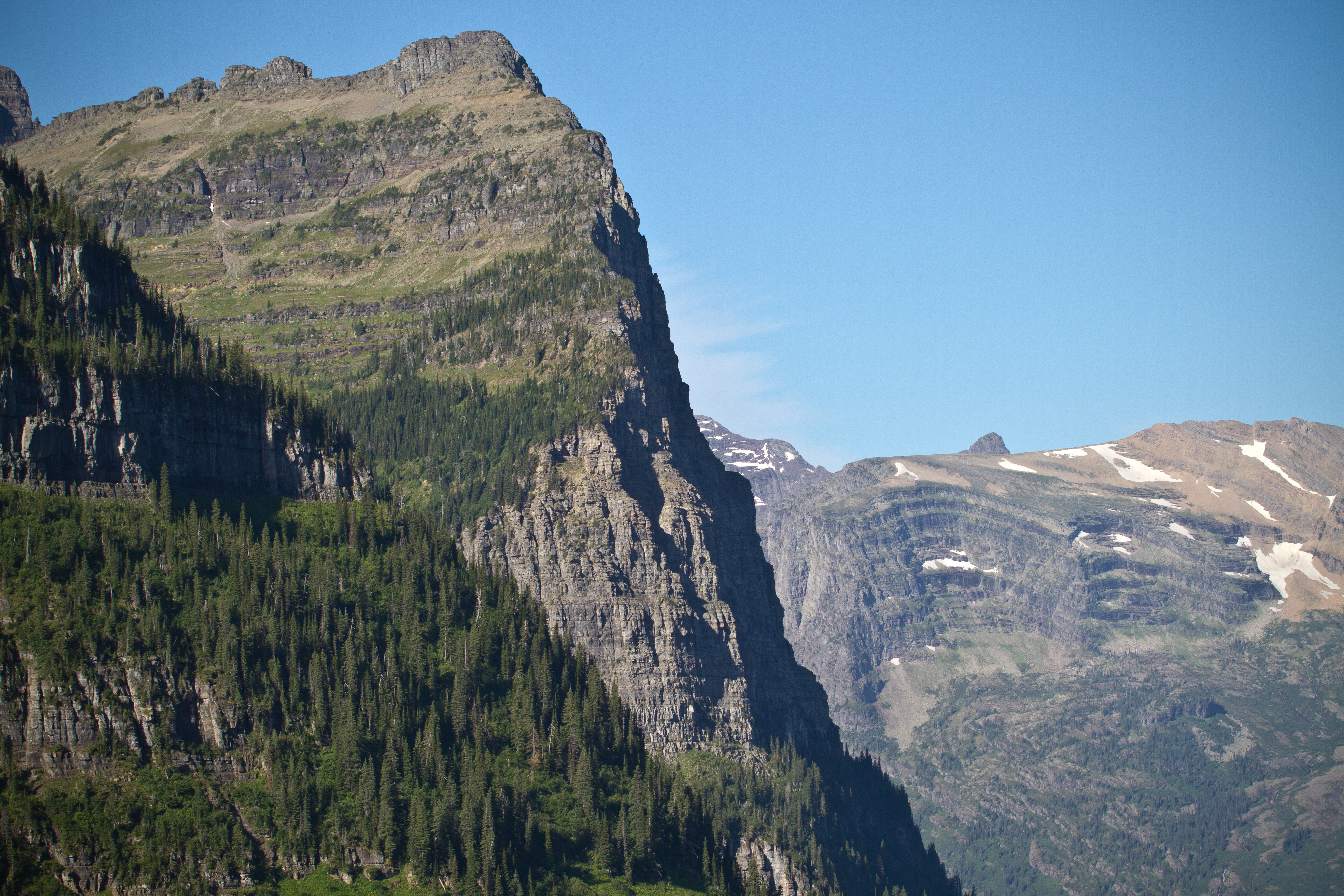 Glacier National Park Trip photos

I appologize for the delay in posting my trip report(s) for the Glacier National Park trip, in the meantime, enjoy some pictures from the trip: Glacier National Park Trip photos
When traveling to North to Franconia Notch on Rt-93, Fill up at exit 28 - Campton, NH (Rt-49).
The Mobil and Gulf gas stations to the East of the highway are frequently much cheaper than the stations closer to the National Park. For example, last weekend, I saw a 20 cents per gallon difference.
The hike up Ammonoosuc Trail was surprisingly easy. I had read stories of how Mt. Washington was tough, how it was more like a western (Rocky) mountain. However, on Ammonoosuc I saw, or felt, none of this.
At the Lake of the Clouds hut, I was feeling so strong, so confident, that I turned away from Mt. Washington and climbed to the summit of Mt. Monroe.
 |
| Lake of the Clouds hut and Mt. Washington, as seen from the side of Mt. Monroe. |
The first thing that greats hikers, as they leave the Lake of the Clouds hut towards Washington, is a weather beaten warning sign: "STOP: The area ahead has the worst weather in America. Many have died there from exposure, even in the summer. Turn back now if the weather is bad."
 |
| The aforementioned warning |
 |
| one of the Lakes of the Clouds |
On the lower steps of Washington, there was a camaraderie amongst us hikers; we chatted, we joked, we laughed together. However as the final mile ground us down with its continuous, demoralizing, unending ascent, we withdrew, one-by-one, into that quiet mental place all athletes know. That place where your mind is clear, pain is ignored, and all that matters is the lifting of the left foot, followed by the right, and repeated ad infinitum.
All that mental stillness is broken by the bustle at the summit. Visitors who drove, or took the Cog Railroad up the mountain, rush around from one side to the next, children screaming or squealing in delight.
I don't want to give the wrong impression, although it was a bit of a shock, the summit experience was not bad. I've been on summits (without roads) that were far more crowded and less personable. Everyone at the top was respectful of the hikers, so much so that one visitor stopped me to congratulate me.
 |
| Mt. Washington Observatory |
 |
| Trail leaving Mt. Washington |
From the naturalists and the family celebrating their patriarchs 60th birthday, to the waterfalls and pools dotting Ammonoosuc, and the birds and other wildlife around Jewel Trail, it was a great day of hiking.
Distance: 9.1 miles
Time: 7 hours 40 minutes
AMC 4k peaks: Mt. Monroe, Mt. Washington
 hiking
 Hovering between Winter and Spring, April gives Yosemite visitors a wonderful mix of weather. During the four days I visited, the temperature ranged from the 20s to the 60s (all temperatures Fahrenheit) with the weather fluctuating from sunny and clear to cloudy and snowing.
 |
| RT-140 heading towards the valley |
The indescribable beauty of Yosemite becomes readily apparent during the long drive into the valley. With the old growth forest to your left and the wondrous vistas to your right, spectacular is the only way to describe the drive.
 |
| "Tunnel View" (RT-140) |
In Yosemite, besides admiring the mountains, visitors should be on the lookout for animals of all kinds. I watched as a pair of deer grazed, unseen, not 30 feet from the Visitors Center; all eyes fixed upwards at the falls.
 |
| Yosemite Falls |
Similarly, while hiking the Valley Loop Trail, I watched a black bear saunter in the opposite direction, not 20 feet from me; either ignorant of, or unimpressed by, my existence. Likewise, as I was leaving the park, I watched a solitary coyote trot along the edge of the RT-140.
 |
| An obscured Yosemite Falls from the Swinging Bridge |
I stayed in Curry Village, a grouping of canvas tent cabins (canvas walls over a wooden structure. Heat is optional, but recommended for an April stay). The accommodations are simple: a cot, blankets, towels, and shared facilities. The experience is unforgettable; The first night I fell asleep to the pitter-patter of rain changing to snow. The second night, I witnessed a waterfall of snow (avalanche) off Glacier Point, the summit that looms behind Curry Village.
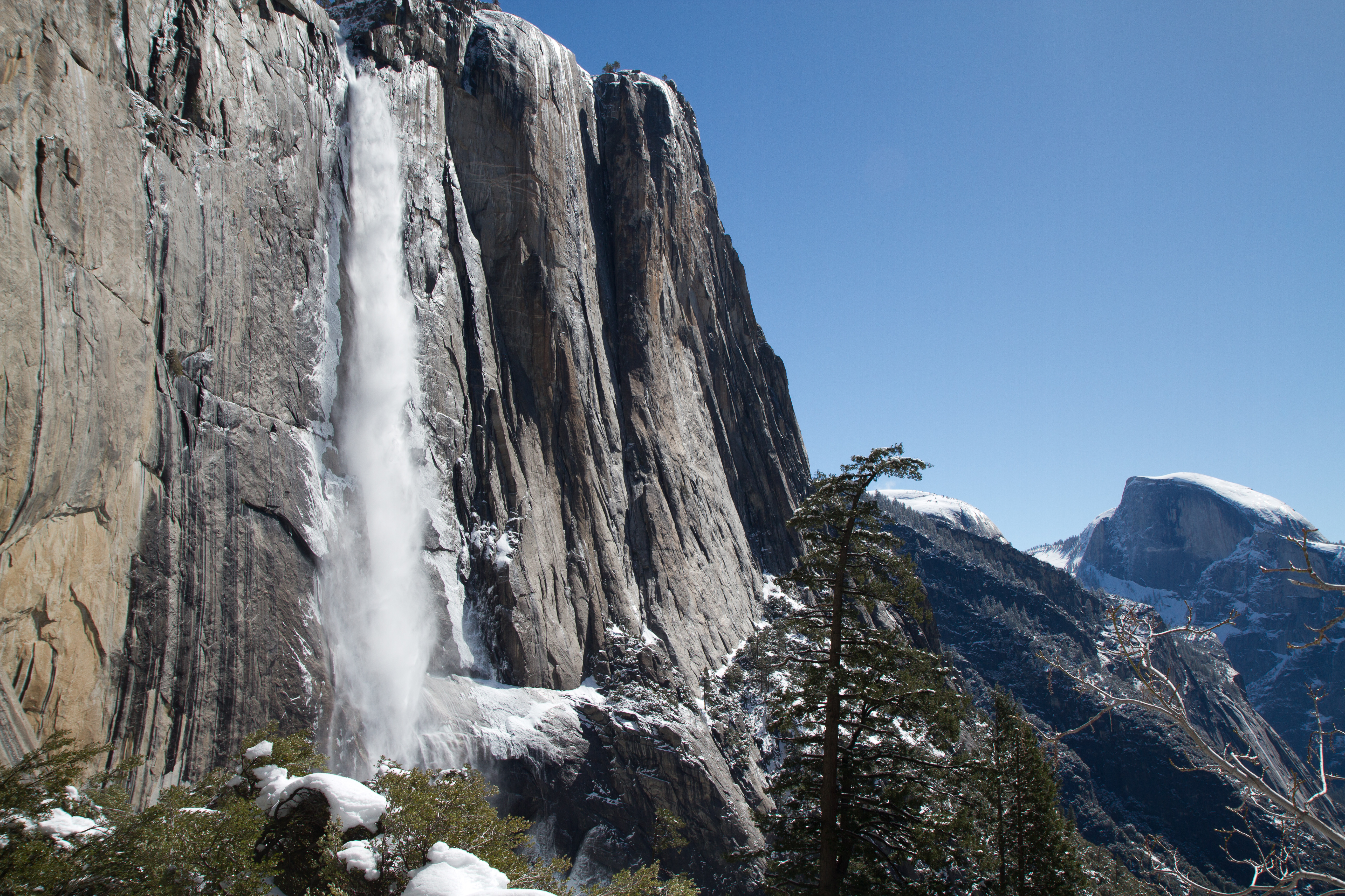 Upper Yosemite Falls and Half Dome, as seen from the Upper Falls trail. Upper Yosemite Falls and Half Dome, as seen from the Upper Falls trail. |
If you only have one day, the views in and out of the park, Lower Yosemite Falls, and the Valley proper will last a life time.
If you have more time, I strongly suggest the Upper Yosemite Trail. The hike is not an easy one, especially in April, but the views are worth it. My only tip: if you struggled to reach Columbia Rock, continue to "the gate." The views of Upper Yosemite Falls from that point make any the suffering worth it.
Like Red Rock State Park, Lost Dutchman State Park is slated to close in June in an effort to alleviate Arizona's budget issues.
 |
| Morning on the Siphon Draw |
The majority of the park's visitors focus on the Siphon Draw Trail. In spring, the trail is awash in a sea of color as flowers scream for attention. And in the Basin, visitors are rewarded with a small desert waterfall.
 |
| The top of The Flatiron |
Most hikers, however, do not complete the whole trail, which ultimately ends 4861ft above sea level at the top of The Flatiron.
In the two miles from the trailhead to the Basin, hikers gain a little over 1000ft in elevation. To reach the top of The Flatiron, you must gain 1760ft in one mile.
 |
| Looking down on/from Siphon Draw |
The first time I visited Lost Dutchman State Park, I (wisely) decided to save The Flatiron for another visit. At that point in the day, I had hiked all the other trails in the park and guessed Siphon Draw's final mile wasn't going to be trivial.
 |
| My Left Foot |
After reaching the top of The Flatiron, I am satisfied with my earlier decision: This is not an easy hike.
Throughout the ascent you need to be very aware of your feet, and confident in their placement. To this end, my choice of footwear helped immensely.
Vibram's FiveFingers KSO Treks are a "shoe" designed to give you all the benefits of barefoot running, walking, and hiking with the protection you expect from footwear. The Treks, specifically, are designed to handle the harshest trails.
These shoes allowed me to easily climb the toughest parts of the trail; I could put all my weight on my toes and feel the stability of my foothold. I could not imagine doing this hike without that feedback.
 |
| Superstition Mountains as seen from Discovery Trail |
In the end, hiking to the top of The Flatiron is difficult, but it is also very rewarding. If you have the time and physical fitness, it is one you should attempt before this park closes in June.
Distance: 6.6 miles
Time: 6 hours 30 minutes
Peaks: The Flatiron, Superstition Mountains (4861 ft)
hiking