For most of this year, I have been focusing on making sure I was prepared for the Mass Pike Bike tour. The idea of doing four days of back to back 65 mile rides, camping in between, concerned me.
Slowly, over the past few months, I have been building my strength up: Increasing the distance, adding weight (to simulate the weight I would be carrying during the tour). This weekend's ride was designed to provide a first look at whether or not my preparations were sufficient.
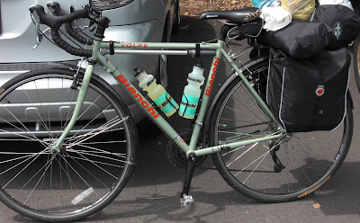
So, at around noon on Saturday (02 August 2008), I loaded the bike up (as seen below) and headed out.
|
| My Volpe with 15lbs of kit. Tent, Sleeping pad, sleeping bag, clothes, rain gear, food, etc. |
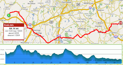
The route I had plotted to follow (see below) was a mix of places I had gone, wanted to go, and would go on the tour.
When I left home, the clear sky was beginning to cloud up. I knew rain was inevitable (radar had it at the MA/NY border), but I was optimistic I could beat it to Palmer, or have it miss me entirely. The key was going to be to keep moving at a steady (if not rapid) clip. Just over 6 miles in, that plan was blown.
Coming down a minor descent (to a stop sign), the harmonics of the decent were such to dislodge the tent from the back rack. Not good. 15 minutes of fiddling I came upon the correct way to secure the tend and sleeping pad (strap them down, looping the sleeping bag's straps on the loops).
For the next two hours, the ride was fairly ordinary. Nothing amazing, interesting, or dangerous occurred, save the clouds getting more and more ominous.
Then, in the middle of Douglas State Park, the first drops hit me. I did my best pro-peloton impression by putting the jersey on without stopping (all the while hearing Phil Liggett in my head saying, "Don't try this at home kids, these are professionals.")
The jacket was great. Prior to the rain the temperature had dropped considerably and I was getting a bit chilled. The jacket provided enough upper body warmth to make things comfortable. Of course, as I progressed west, deeper into the storm, that comfort became very relative.
Not much to say about riding through the storm, just a few observations:
- Use a rear light when riding in the rain - The way I had packed my gear made it impossible for me to mount by rear blinky. This made rain travel very dangerous. Cars without lights on disappeared into the rain in less than 200ft, so I knew I was invisible to traffic. Reflective material only works if the car luminates them.
- Fenders only do so much - No fender is going to protect you from spray when you are descending at 30mph in the runoff. Furthermore, in that situation there is nothing you can do to prevent your shoes from getting soaked (save wear booties/shoe covers).
- The cops in Dudley are cool - The first phase of nasty rain had passed as I rolled through this town. One of the officers gave me a sharp salute as I passed, which I thought was very cool.
- Never assume a road has a breakdown lane - When I set the route up, I assumed Route 20 would have a breakdown lane. For most of the road the speed limit is 55 and has two lanes in each direction, for all intents and terms a highway. Guess what. I doesn't have a breakdown lane. So after 50 miles of riding, this soaked rider had to take a whole lane on a highway and deal with the consternation of passing motorists. Fortunately, the rain had stopped and traffic was light, so no one even had to slow down to pass me, just pop in the next lane.
- Google Maps doesn't warn you about bridge closures - 62 Miles in, as I approached one of my turns, I was greeted with the dreaded "Bridge Out" sign. Tired, I stop and read the two paragraph long detour instructions. At that point I decide to give it a go, the bridge must be out for car weight, a bike and rider can't be too much for it right? I coast down to the metal grate bridge, lift the bike over the concrete barriers, and slowly walk it across. At the halfway point the bridge begins to creak under our combined weight; at which point I make a mental note ("In future, abide by bridge closure warnings").
All in all a good ride. Physically the ride wasn't that physically demanding, although slowing down during the rain storms probably ensured that fact.
Distance:  67.78 miles
Ave Speed: 13.2 mph
Max Speed: 32.7 mph
Time: 5 hours 6 minutes 59 seconds

 fred
fred